
About Us
Naivasha Constituency
Population of Naivasha: 224,141 people
Latitude of Naivasha: -0,7167 (043'0.001"S)
Longitude of Naivasha: 36,4333 (3625'59.880"E)
Altitude of Naivasha: 2 084 m
GMT time in Naivasha: +3 hours
Naivasha Constituency is located within Nakuru County. It has a population of about 224,141 covering about 425.48 kilometre squares.
Its neighbour’s Kajiado South Constituency, Lari Constituency, Narok East Constituency, Gilgil constituency, Lari Constituency and Nyandarua South Constituency.
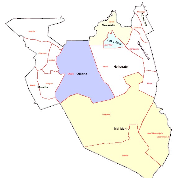
Naivasha Constituency has eight wards namely Mai Mahiu ward, Olkaria ward, Viwandani ward, Naivasha East ward, Lake View ward, Bashara ward, Maela ward and Hells Gate Ward.
Naivasha Constituency is well endowed with natural resources due to its Geographical position, which includes Lake Naivasha, Mt Longonot, Kikuyu Escarpments, Hells Gate National Park and Geothermal wells in Olkaria making it hospitality hub for both local and international tourists in the country in addition to serious investments and settlements all over Naivasha.
The major economic activities in Naivasha Constituency (Sub County) are;
Beef Cattle Farming
Mining/Quarrying
Dairy Cattle Farming
Poultry Farming
Business and Investment.
Fishing
Real Estate Business
Tourism and Recreation
Greenhouse Agriculture
Horticulture and Floriculture
Pyrethrum Farming
Onions, Cabbages, Sukuma wiki, fruits farming etc
Access NG-CDF Information on your Mobile


County Assembly Wards in Naivasha Constituency:
Naivasha East Ward
- County Assembly Ward No.:
- County Assembly Ward Name: Naivasha East
- County Assembly Ward Population (Approx.): 20,884
- County Assembly Ward Area In Sq. Km (Approx.):
- County Assembly Ward Description: comprises of Munyu and Maraigushu.
Hells gate Ward
- County Assembly Ward No.:
- County Assembly Ward Name: Hells gate
- County Assembly Ward Population (Approx.): 39,209
- County Assembly Ward Area In Sq. Km (Approx.):
- County Assembly Ward Description: comprises of Mirera.
Mai Mahiu Ward
- County Assembly Ward No.:
- County Assembly Ward Name: Mai Mahiu
- County Assembly Ward Population (Approx.): 29,796
- County Assembly Ward Area In Sq. Km (Approx.):
- County Assembly Ward Description: comprises of Satelight, Kijabe and Longonot.
Maeilla Ward
- County Assembly Ward No.:
- County Assembly Ward Name: Maeilla
- County Assembly Ward Population (Approx.): 27,528
- County Assembly Ward Area In Sq. Km (Approx.):
- County Assembly Ward Description: comprises of Kongoni, Maeilla, Moi Ndabi, Kipkonyo and Ndabibi
Biashara Ward
- County Assembly Ward No.:
- County Assembly Ward Name: Biashara
- County Assembly Ward Population (Approx.): 15,692
- County Assembly Ward Area In Sq. Km (Approx.):
- County Assembly Ward Description: comprises of Mununga and Kinamba.
Viwandani Ward
- County Assembly Ward No.:
- County Assembly Ward Name: Viwandani
- County Assembly Ward Population (Approx.): 45,513
- County Assembly Ward Area In Sq. Km (Approx.):
- County Assembly Ward Description: comprises of Sokoni.
Lakeview Ward
- County Assembly Ward No.:
- County Assembly Ward Name: Lakeview
- County Assembly Ward Population (Approx.): 20,082
- County Assembly Ward Area In Sq. Km (Approx.):
- County Assembly Ward Description: comprises of Lake View
Olkaria Ward
- County Assembly Ward No.:
- County Assembly Ward Name: Olkaria
- County Assembly Ward Population (Approx.): 25,437
- County Assembly Ward Area In Sq. Km (Approx.):
- County Assembly Ward Description: comprises of Olkaria